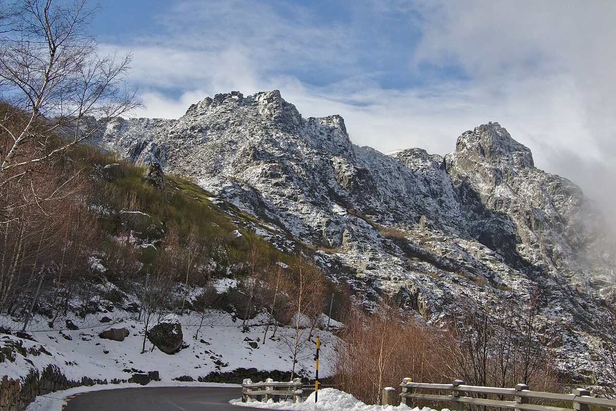
Most English-language guides to Portugal run out of road somewhere east of Coimbra. They cover the coast in exhaustive detail, give the Serra da Estrela a paragraph about snow and cheese, and leave the rest of the interior, the granite border country the Portuguese call the Beira Interior, almost blank. That’s a shame, because this is where mainland Portugal climbs to its highest point, where a glacier carved a valley you can now drive along, where a village is built under boulders the size of houses, and where a chain of fortified hilltop towns spent seven centuries watching Spain. This guide covers the mountain and the twelve Historic Villages around it: the roads, the walks, the food, the prices that can actually be confirmed, and an honest view on what isn’t worth the drive.
The short answer: the Serra da Estrela is mainland Portugal’s highest mountain range, topping out at Torre (1,993 m), about three hours’ drive from Lisbon. Give it two or three nights based in Manteigas or Covilhã. Drive the glacial valley and the road over Torre, walk to Covão dos Conchos, eat the cheese, then add Monsanto, Sortelha and Belmonte.
Serra da Estrela and the interior at a glance
Drive times are from Manteigas, the most central base, in normal conditions; add time in winter, when the high roads can close. They’re approximate, and the mountain roads are slow. Prices were checked in October 2026. Most of this region costs nothing to see.
| Place | What it is | From Manteigas by car | Time needed | Cost | Verdict |
|---|---|---|---|---|---|
| Zêzere glacial valley and Covão d’Ametade | A U-shaped glacial valley with a birch meadow at its head | ~20 min | Half a day | Free | The single best thing on the mountain |
| Torre and the N339 | Mainland Portugal’s highest point and highest road | ~40 min | 2–3 h with stops | Free | Go for the drive, not the summit car park |
| Covão dos Conchos | A mountain lake with a round spillway, reached on foot | ~1 h to Lagoa Comprida, then walk | 3–4 h | Free | The walk everyone does; go early |
| Poço do Inferno | A waterfall in a granite gorge | ~20 min | 1 h | Free | Best after rain, or frozen in a hard winter |
| Ski area at Torre | Portugal’s only ski runs | ~40 min | A day | Day pass €15–30 (sources disagree) | Fun for snow, not a ski holiday |
| Covilhã | Wool town, university, street art | ~45 min | Half a day | Wool museum ticketed | The practical base for trains and skiing |
| Seia and Sabugueiro | Bread museum, cheese stalls, the “highest village” | ~1 h | Half a day | Museums ticketed | Good on the way over the top |
| Belmonte | Cabral’s birthplace and Portugal’s crypto-Jewish community | ~35 min | 2–3 h | Museums ticketed | The richest history of any Historic Village |
| Sortelha | A complete walled granite village | ~1 h | 2 h | Free | The best-preserved walls of the twelve |
| Monsanto | A village built among and under granite boulders | ~1h30 | Half a day; better a night | Free | The most extraordinary village in Portugal |
| Idanha-a-Velha | A Roman town with a Visigothic cathedral | ~1h30 | 1–2 h | Free to walk | Pair it with Monsanto |
| Almeida | A star-shaped fortress on the Spanish border | ~1h30 | 2 h | Free to walk | A masterpiece of military engineering |
| Piódão | Schist village stacked up a terraced hillside | ~2 h, winding | Half a day; better a night | Free | Worth the drive if you sleep there |
| Talasnal and the Lousã schist villages | Slate hamlets in chestnut woods | ~2h30 | Half a day | Free | The easiest schist villages to reach |
What and where the Serra da Estrela is
The Serra da Estrela is a long granite and schist massif running north-east to south-west across the middle of the country, roughly halfway between the Atlantic and the Spanish border. It isn’t a range of sharp peaks. The top is a high, rolling plateau at around 1,700–1,990 metres, scraped bare by ice, strewn with boulders and dotted with small glacial lakes, and the drama is at its edges, where the plateau breaks into deep valleys. On the east side, the Zêzere runs through the finest glacial valley in Portugal. On the west, the land drops in long ridges towards Seia and the Dão wine country. Two of Portugal’s most important rivers rise up here: the Zêzere, which feeds the Tagus, and the Mondego, the longest river entirely within Portugal, which flows out to the sea at Figueira da Foz after passing Coimbra.
Local legend says the mountain was named by a shepherd who followed a bright star to the summit with his dog, and the region’s great sheepdog, the shaggy, lion-headed Cão da Serra da Estrela, carries the name too. The less romantic truth is that this was always shepherds’ country. For centuries, flocks were walked up to the summer pastures on the plateau and down again for winter, and the cheese, the wool industry in Covilhã and even the shape of the villages all come from that.
Two designations cover the mountain, and they’re worth getting straight because search results muddle them. The Serra da Estrela Natural Park (Parque Natural da Serra da Estrela) was created in 1976 and covers close to 900 square kilometres of the range. People often search for a “Serra da Estrela national park”, but Portugal has only one national park, Peneda-Gerês in the far north; everything else, this included, is a natural park, which means people live and farm inside it and there are no entry fees or gates. Since 2020 the mountain and its surrounding towns have also been the Estrela UNESCO Global Geopark, recognised for its glacial landscape, which is the best preserved in Portugal.
The towns sit around the edge of the massif rather than on it. Covilhã is on the south-eastern slope, the biggest town and the closest to the ski area. Manteigas lies inside the mountain at the foot of the glacial valley. Seia and Gouveia are on the western side, Guarda to the north-east, and Belmonte to the east, overlooking the wide valley of the Cova da Beira. Beyond them, out towards Spain, is the border country of the Historic Villages, the subject of the second half of this guide. Together this is what Portuguese tourism calls the interior: the least-visited part of the mainland, the oldest, the most depopulated, and to my mind one of the most rewarding.
Torre and the high plateau
Torre, the top of mainland Portugal
At 1,993 metres, Torre is the highest point of mainland Portugal (Pico, in the Azores, is higher still at 2,351 m). The name simply means “tower”, and the story goes that King João VI had a stone tower raised on the summit so that the country’s highest point would reach a round 2,000 metres. What you find there today is a broad granite dome given over to a large car park, two white radar domes, the small stone tower itself and a row of shops selling cheese, smoked hams, sheepskins and fleece blankets. On a clear day the view runs across the plateau to the sierras of Spain and down over the Cova da Beira; on a cloudy day you’ll see the shop opposite.
Verdict: the summit is the least interesting place on the mountain. Drive through it rather than to it, stop for the view if there is one, and spend your time on the roads either side.
The N339, Portugal’s highest road
The road that crosses the top, the N339, is the best drive in central Portugal. From Covilhã it climbs in long switchbacks to the old health resort of Penhas da Saúde, founded for tuberculosis patients who came up for the mountain air, then on past the Nossa Senhora da Boa Estrela, a seven-metre figure of the Virgin carved into a granite rock face in 1946, which is the focus of a pilgrimage every August. Above it, the road passes under the sheer granite of the Cântaro Magro before reaching Torre. On the far side it drops across the western plateau, past the dam and lake of Lagoa Comprida, through the village of Sabugueiro and down to Seia. Covilhã to Seia is about 50 km, and with stops it fills a morning.
In winter the stretch over the top closes several times a season with snow and ice, sometimes for days. A snow-clearing centre at Piornos works the road, but you should check the road status with Infraestruturas de Portugal or the local news before driving up between December and March, and carry chains, which the police can require when the road is open on snow. In summer the same road is full of cyclists; the Volta a Portugal has finished stages at Torre, and riding up from Covilhã is a local rite of passage.
Verdict: drive it in daylight on a clear day, and if you have the choice, cross it in the morning before the cloud builds over the plateau.
Lagoa Comprida and Covão dos Conchos
Lagoa Comprida, at around 1,600 metres on the western side of the N339, is the biggest lake on the mountain: a natural glacial lake raised by a dam for hydroelectric power. It’s pretty but not the point. From near the dam, a track heads north-east across the plateau to Covão dos Conchos, a small reservoir whose spillway is a perfectly round bellmouth in the water: a funnel built in the 1950s to drain the lake through a tunnel towards Lagoa Comprida. Photographs of it, looking like a hole punched in the surface of the lake, spread around the internet a few years ago, and it is now the most popular walk in the Serra da Estrela.
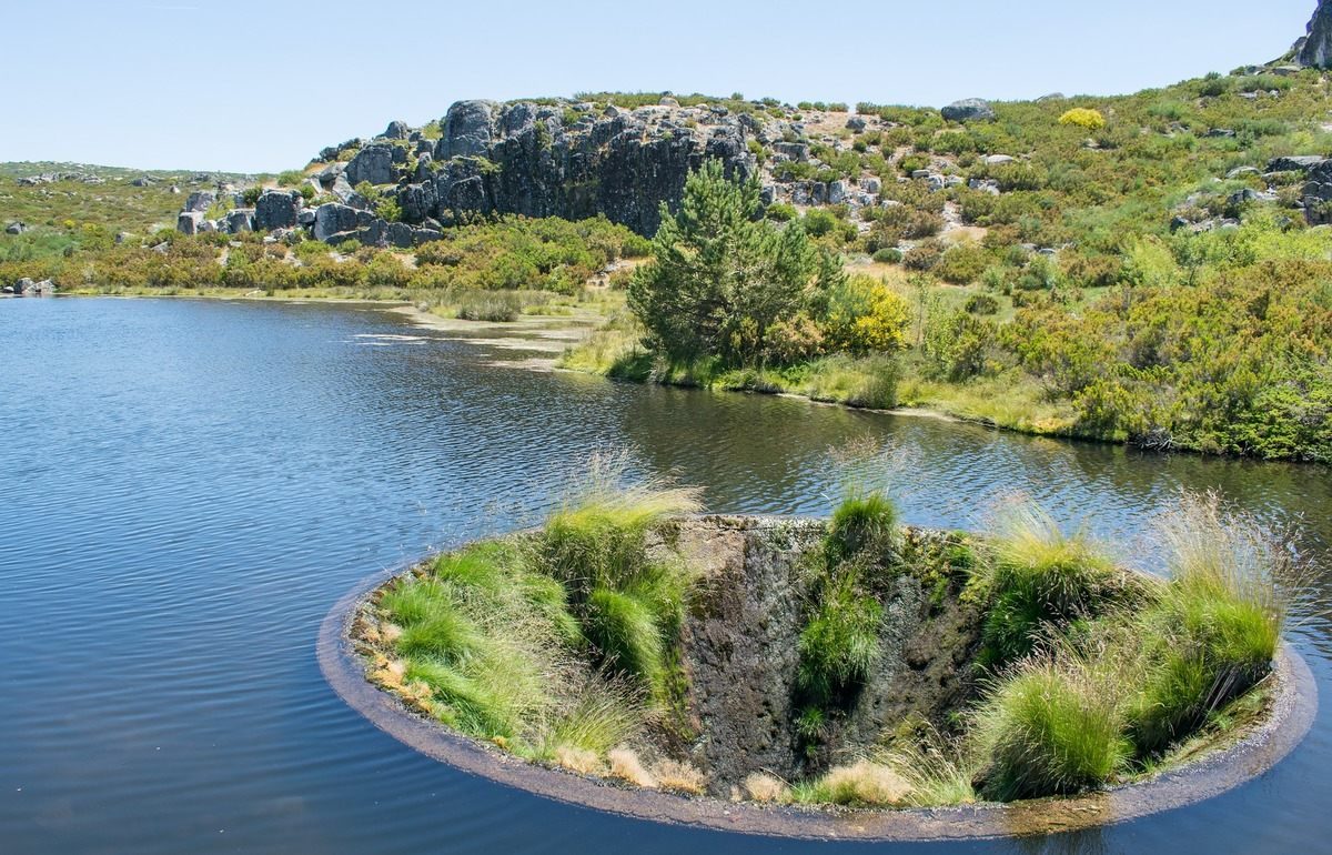
The walk is roughly 8–9 km there and back on a broad, mostly gentle track, about two and a half to three hours with time at the lake. There is no shade at all, and the plateau can disappear into fog in minutes, so carry water and a downloaded GPS track. How the spillway looks depends on the season: in late spring, when the lake is full, water pours into it; in dry late summer it can sit above the water as a grassy ring; in winter it may be frozen or buried in snow. Verdict: worth it, but go early. By late morning on a summer weekend there are dozens of people queuing for the same photograph.
The Cântaros and the plateau lakes
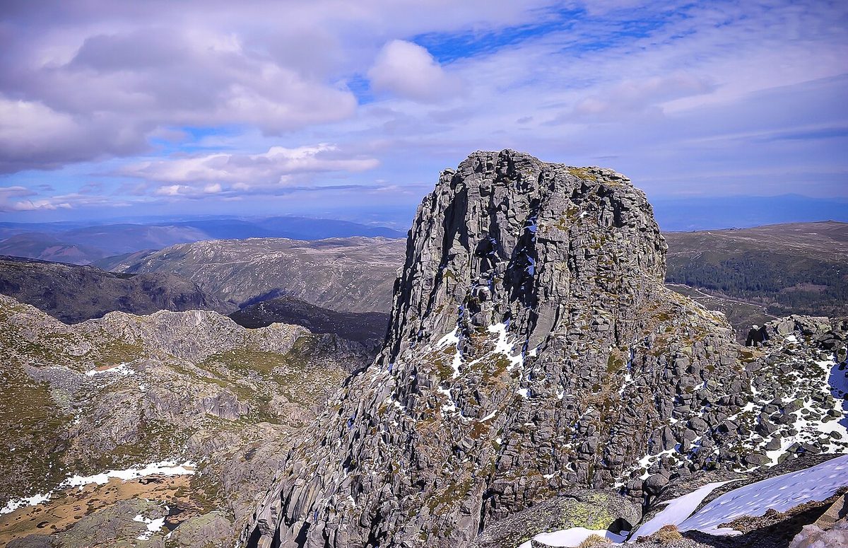
Above the head of the Zêzere valley stand the three Cântaros, granite peaks whose name means “pitchers”: Cântaro Magro, the thin one, with its sheer, climbable face; Cântaro Gordo, the fat one; and the flatter Cântaro Raso. They’re the most dramatic rock scenery on the mountain, and you see them best from the N339 between Torre and Penhas da Saúde, or from the meadow at Covão d’Ametade far below. Between Torre and Lagoa Comprida, the plateau holds a string of small glacial lakes (Lagoa Escura, Lagoa Redonda, Lagoa do Peixão and others) linked by walking routes across open granite, which feel more like the Scottish Highlands than anywhere in southern Europe.
Manteigas and the Zêzere glacial valley
The Zêzere glacial valley
During the last ice age, an ice cap covered the plateau and a glacier around 13 km long flowed north-east from it down to where Manteigas now stands, carving a textbook U-shaped trough with steep granite walls and a flat floor. The Vale Glaciar do Zêzere is the clearest glacial landscape in Portugal, and you can drive straight along it: the N338 climbs from Manteigas up the valley floor and then zigzags out of its head to join the N339 below Torre. The views back down the valley from the hairpins near the top are the best on the mountain.
In August 2022, a wildfire burned well over 20,000 hectares of the natural park, including slopes of the glacial valley above Manteigas. You’ll still see the scars, though regrowth is well under way, and it’s worth knowing that summer fire risk is the main reason trails and roads are occasionally closed at short notice in July and August.
Covão d’Ametade
At the head of the valley, where the infant Zêzere runs out of the rock, is Covão d’Ametade: a flat meadow of grass and silver birch at the foot of the Cântaro Magro, with picnic tables, a stream and the granite walls of the cirque rising on three sides. It’s the classic Serra da Estrela picnic spot and the start of several walks, including the steep climb up towards the Cântaros. On summer weekends Portuguese families fill it by lunchtime; on an October weekday, when the birches turn gold, you may have it to yourself.
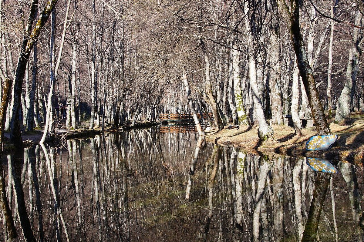
Verdict: the single best place on the mountain. Come early, bring a picnic, and walk at least a short way up the valley.
Poço do Inferno
A short, narrow road climbs from Manteigas through pine woods to Poço do Inferno, “hell’s well”, a waterfall dropping into a pool in a granite gorge. It’s at its best after heavy rain, or in a hard winter, when it freezes into a curtain of ice that makes the local news. In a dry August it’s a trickle. You can also walk up from Manteigas on a waymarked route through the woods, which makes a good half-day. Verdict: lovely in the right season; check how much rain there has been before you go.
Manteigas
Manteigas is a small spa town at around 700 metres, sitting where the glacial valley opens out, and it’s the best base on the mountain for anyone who wants to walk. It has a thermal spa, a handful of good restaurants serving trout and feijoca (a stew of big white runner beans with pork that’s the town’s dish), and the Burel factory, an old wool mill revived to weave burel, the thick felted wool cloth shepherds once wore, into blankets, bags and upholstery. Above the town to the north, Penhas Douradas is a scattering of houses on a high shoulder with long views, and nearby Vale do Rossim is a reservoir at roughly 1,400 metres with a sandy summer beach, a lake you can swim in and a small eco-resort. Verdict: base yourself here for two or three nights if you’re walking.
Covilhã, Seia, Gouveia and Guarda: the towns around the mountain
Covilhã
Covilhã climbs up the south-eastern slope of the mountain so steeply that its streets are a workout. For two centuries it was Portugal’s wool town, and the Museu de Lanifícios, the wool museum, is set in the old royal cloth factory founded under the Marquis of Pombal in 1764, now part of the University of Beira Interior; it’s one of the best industrial museums in the country, with the original dye vats still in the floor. Since 2011 the WOOL urban art festival has covered the town’s blank walls in large murals, many of them on wool and shepherding themes, and you can follow them on foot. The modernist footbridge over the Carpinteira ravine, by the architect João Luís Carrilho da Graça, is worth a look too.
Covilhã is the most practical base on the mountain: it’s on the railway from Lisbon, it has the most hotels and restaurants, and it’s the closest town to the ski area, about 20 km up the N339. At Penhas da Saúde, above the town, an old railway workers’ sanatorium has been converted by the Pritzker-winning architect Eduardo Souto de Moura into the Pousada da Serra da Estrela. Verdict: base yourself here if you’re arriving by train or coming for snow; it’s less charming than Manteigas but more convenient.
Seia and Sabugueiro
On the western side, Seia is the start (or end) of the N339 and home to the Museu do Pão, a large, well-done bread museum with a shop and restaurant, which children tend to enjoy more than adults expect. The town also has the CISE, the Serra da Estrela interpretation centre, which is a good first stop for understanding the geology and wildlife, and a toy museum. Up the road at around 1,050 metres, Sabugueiro bills itself as the highest village in Portugal. It’s a working village with a strip of stalls along the road selling cheese, cured meats, honey, liqueurs, sheepskins and, regrettably, puppies. Verdict: stop in Seia for the bread museum, and buy cheese in Sabugueiro from a stall that shows the DOP label (more on that below).
Gouveia, Folgosinho and Linhares da Beira
Gouveia, north of Seia, is a pleasant granite town with a modern-art museum dedicated to the painter Abel Manta, and the road from it over the mountain to Manteigas, via Penhas Douradas, is a fine alternative to the N339. In the hills behind it, Folgosinho is a tiny village with a castle-topped rock and a reputation for enormous set lunches. Linhares da Beira, a few kilometres further north, is one of the twelve Historic Villages: a granite village under a castle built on a rock, and Portugal’s best-known paragliding launch site, so on summer afternoons the sky above it is full of wings. Verdict: Linhares is worth an hour; the others are good stops on a slow drive.
Loriga
On the south-western flank, Loriga sits on a spur at the mouth of its own glacial valley, a dramatic site that earned it the old nickname “the Portuguese Switzerland”. The village has terraced fields climbing above it, a river beach built into the rocks of the stream, and walks up the valley towards the plateau. It’s at the end of a long road from anywhere, which keeps it quiet. Verdict: a good detour for walkers and for anyone driving between Seia and Piódão.
Guarda
Guarda, at around 1,056 metres, is the highest city in Portugal, and the local saying gives it five Fs: forte, farta, fria, fiel e formosa (strong, plentiful, cold, faithful and beautiful). The cold is real. Its granite cathedral, begun in 1390 and finished some 150 years later, looks more like a fortress than a church, with Gothic, Manueline and Renaissance stages stacked on top of each other, and the old town around it is compact and walkable. Verdict: the best base for the northern Historic Villages (Almeida, Castelo Rodrigo, Castelo Mendo, Trancoso and Marialva) and an easy stop on the A25 from Porto or from Spain.
Snow and skiing in the Serra da Estrela
When it snows
The Serra da Estrela is the only place in mainland Portugal where snow settles reliably every winter, and that alone draws Portuguese families up the mountain in their thousands. The high plateau usually gets its first snow between November and December, and the best chance of snow on the ground is from late December to March; it can fall on the summit as late as April or May. How much falls varies enormously from year to year, and a mild, dry winter can leave the plateau patchy and brown even in January. If snow is the point of your trip, watch the forecasts and the resort’s social media and go at short notice.
The ski area
The ski area sits on the slopes just below Torre and is the only one in Portugal. It’s small: a few short, mostly gentle runs served by chairlifts and drag lifts, with ski school, equipment hire and snowmaking to stretch the season, which typically runs from late December or January into March, snow permitting. Third-party listings disagree on the price. One quotes a main-season day pass at €30 for adults and €20 for children; another quotes €25 in high season (weekends and school holidays) and €15 in low season, with a five-day low-season pass at €65. The resort’s own website doesn’t publish a readable price list, so treat those figures as a guide, checked in October 2026, and confirm at the ticket office.
Verdict: great fun for a day if you’re already in Portugal in winter, and a good place for children to have a first go on skis. It isn’t a ski holiday, and nobody should fly to Portugal to ski: the runs are short, the queues at weekends are long, and the conditions depend on luck.
Snow without skis
Most people who come up in winter don’t ski at all. They sledge, build snowmen, throw snowballs and photograph each other on the plateau around Torre, where sledges and snow gear are sold or hired from the shops. The meadow at Covão d’Ametade, the slopes above Penhas da Saúde and the lakes on the plateau are all beautiful in snow, and the frozen spillway at Covão dos Conchos has become a winter pilgrimage of its own, though the walk there in snow needs boots, warm layers and a clear forecast. Our guide to Portugal with kids has more on making a snow day work with small children.
Driving up in winter
On a snowy weekend, the roads up from Covilhã and Seia become one long queue, the car parks at Torre fill early, and the police turn cars without chains back. The N339 over the top, and the N338 up the glacial valley from Manteigas, can be closed for hours or days after heavy snow. My advice: go midweek if you possibly can, set off early, carry chains you’ve practised fitting, and check the road status before you leave. Hire-car companies usually don’t include chains, so ask when you book.
Walking in the Serra da Estrela
The Serra da Estrela has the best high-mountain walking on the mainland, with a network of waymarked short routes (PR) and longer routes (GR) radiating from Manteigas, Loriga, Seia, Covilhã and the plateau. It’s not alpine; the paths are mostly good and the climbs modest. What makes it serious is the weather. The plateau is open and shadeless, fog can roll in within minutes, there are few landmarks once the cloud is down, and conditions change fast at any time of year. Carry water, layers, a map or GPS track and a charged phone, and don’t set off across the plateau if the forecast is uncertain. These are the walks I’d prioritise.
- Lagoa Comprida to Covão dos Conchos. Roughly 8–9 km there and back, mostly gentle; 2.5–3 hours. The famous one, described above. Go early.
- Covão d’Ametade and the glacial valley. Easy strolls along the valley floor from the meadow, or a steep climb towards the Cântaros for the views. A half-day of your choosing.
- Manteigas to Poço do Inferno. A waymarked climb through pine and oak woods to the waterfall; a half-day, with the option of returning by road if someone can collect you.
- The Loriga valley. From Loriga up its glacial valley towards the plateau lakes; as long or short as you like, with a steep upper section.
- The plateau lakes from Torre. Open walking across the granite between Torre and Lagoa Comprida, linking the small glacial lakes. Beautiful in clear weather and genuinely risky in fog.
- Penhas Douradas and Vale do Rossim. Gentle walks on the northern shoulder above Manteigas, with a swim at the end in summer.
Spring and autumn are the best seasons: in May and June the mountain is green, the streams are full and the slopes turn yellow with flowering broom, and in October the birches and chestnuts colour. Midsummer is fine on the plateau early in the day but hot in the valleys, and winter walking on the high ground needs experience and the right kit. For the rest of the country’s trails, from the Rota Vicentina to Peneda-Gerês, see our hiking guide to Portugal.
One warning that doesn’t appear in most guides: the flocks on the mountain are guarded by big working dogs, usually Estrela Mountain Dogs, whose job is to see off anything that approaches the sheep. They are not pets. Give flocks a wide berth, don’t walk between the dogs and the sheep, and if a dog comes towards you barking, stop, stay calm and back away slowly.
Cheese, bread and mountain food
The Serra da Estrela’s most famous export isn’t the snow. Queijo Serra da Estrela is Portugal’s best-known cheese and one of its finest: a soft cheese made from the raw milk of the mountain’s own sheep breeds, curdled not with animal rennet but with the flowers of the wild cardoon thistle, which gives it a faint, pleasantly bitter edge. It’s made in the cold months, roughly November to April, and at its peak it’s amanteigado, buttery, with a centre so runny that the classic way to eat it is to cut a lid off the top and scoop the inside out with a spoon onto bread. Left to age, it becomes the firmer, sharper queijo velho.
The genuine cheese carries a DOP (protected designation of origin) label. The shops at Torre and the roadside stalls sell plenty of cheaper cheese “tipo Serra”, in the Serra style, and some of it is perfectly nice, but it isn’t the same thing; check the label before you pay DOP prices. Cheese fairs are held in late winter, roughly February to April, in Seia, Celorico da Beira, Gouveia, Oliveira do Hospital and other towns of the cheese area, with tastings, sheep competitions and a lot of bread and wine. Dates move each year, so check the municipalities’ pages.
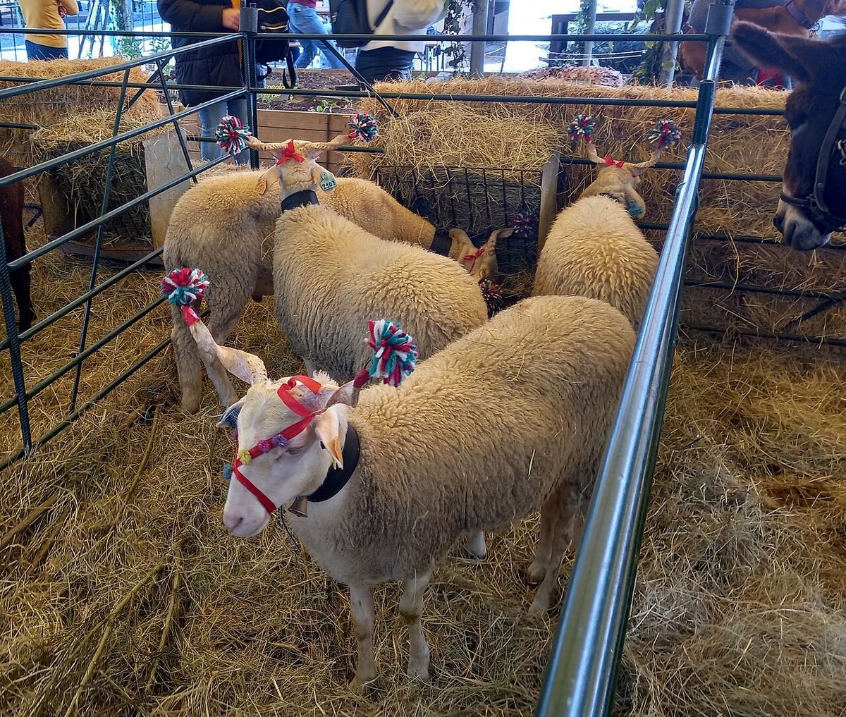
The rest of the mountain’s food is built for cold weather. Look for requeijão, a fresh whey cheese eaten with pumpkin jam; smoked and cured pork, from presunto ham to chouriço and morcela blood sausage; bucho, a stuffed pig’s stomach that’s better than it sounds; roast kid (cabrito) and lamb; trout from the mountain streams; and Manteigas’s feijoca. Rye and maize bread is still baked in wood ovens. In late May and June, the orchards of the Cova da Beira around Fundão produce the best cherries in Portugal, and in autumn there are chestnuts roasted at the magustos around São Martinho on 11 November. The wines are from the Beira Interior, on the eastern side, and the Dão, which reaches up the western slopes towards Seia and Gouveia. Our Portuguese food guide covers the country’s dishes region by region.
Why the border country is full of castles
To make sense of the Historic Villages, it helps to know why there’s a fortress on almost every hill east of the Serra da Estrela. This was the frontier. After the Christian kingdoms pushed south in the twelfth and thirteenth centuries, the young kingdom of Portugal’s eastern edge faced León and then Castile, and its kings granted charters to settlers and built or rebuilt castles all along the line. The land east of the river Côa, around Almeida and Castelo Rodrigo, only became Portuguese for good with the Treaty of Alcañices in 1297, under King Dinis, the same king who married Isabel of Aragon in Trancoso in 1282.
The border stayed live for centuries. In 1492, thousands of Jews expelled from Spain crossed into these towns; when Portugal forced conversions in 1497, some families in Belmonte and nearby kept their faith in secret for over four hundred years. In the war that followed Portugal’s restoration of independence from Spain in 1640, the castles were rebuilt for artillery, which is why Almeida became a star-shaped fortress. And during the Peninsular War, French armies marched straight through this country: in 1810 Masséna’s siege of Almeida ended when the fortress’s powder magazine exploded, destroying the castle and killing hundreds of defenders.
In the twentieth century, the region emptied. People left for Lisbon, France, Germany and the Americas, and many of the villages were half-abandoned by the 1980s. The Historic Villages network began in the 1990s with ten villages, with Belmonte and Trancoso added later, to restore them and bring visitors back. It’s worked unevenly: some villages now have good guesthouses and restaurants; others still have more stones than people. That’s part of their appeal.
The 12 Historic Villages of Portugal
The twelve Historic Villages are Almeida, Belmonte, Castelo Mendo, Castelo Novo, Castelo Rodrigo, Idanha-a-Velha, Linhares da Beira, Marialva, Monsanto, Piódão, Sortelha and Trancoso. They’re spread across a wide area, from the Serra do Açor in the west to the Spanish border in the east, and a long-distance waymarked loop of several hundred kilometres, the GR22, links them all. You don’t need to see all twelve. Here’s how I’d rank them for a first visit.
| Village | Best for | Time needed | Verdict |
|---|---|---|---|
| Monsanto | Boulder houses, castle views | Half a day or a night | The unmissable one |
| Sortelha | Complete medieval walls | 2 h | The most atmospheric at dusk |
| Piódão | Schist houses on a terraced slope | Half a day or a night | Spectacular, but far from the rest |
| Belmonte | Jewish history, Cabral, museums | 2–3 h | The best for history |
| Almeida | Star fortress | 2 h | Best understood from the walls |
| Castelo Rodrigo | Border views, almond blossom | 1–2 h | Lovely in February and March |
| Trancoso | Walls, Jewish quarter, food | 2 h | The liveliest, a real small town |
| Idanha-a-Velha | Roman and Visigothic remains | 1–2 h | Pair it with Monsanto |
| Linhares da Beira | Castle, paragliding | 1 h | An easy add-on from Gouveia or Guarda |
| Marialva | Ruined citadel on a rock | 1 h | Romantic ruins, little else |
| Castelo Novo | Granite village, baroque fountain | 1 h | Quiet and pretty |
| Castelo Mendo | Tiny walled village | 45 min | Only if you’re passing |
Monsanto
Monsanto climbs a lone granite hill rising out of the plains near the Spanish border, and its houses are built between, against and underneath enormous boulders: some use a boulder as a wall, some as a roof, and one or two seem to be holding the rock up. In 1938 it won a national competition for “the most Portuguese village in Portugal”, and a silver rooster, the trophy, still sits on top of its clock tower. A steep path climbs from the village through the boulders to the ruined castle, with views over the plain towards Spain. On 3 May, at the Festa das Cruzes, women carry the rag dolls called marafonas and a pot of flowers is thrown from the castle walls, a re-enactment of a legend in which the starving defenders threw their last calf at the besiegers to convince them that the village could hold out forever.
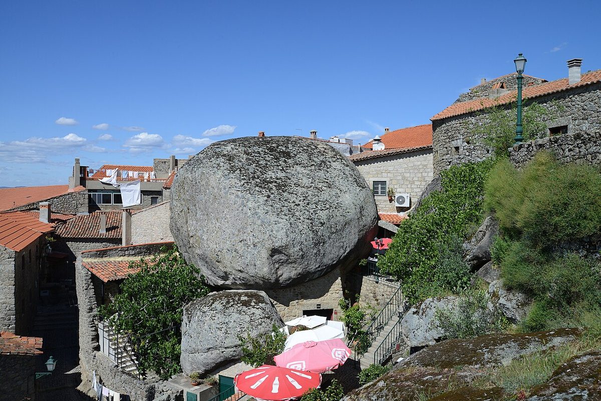
Monsanto is within the Naturtejo UNESCO Global Geopark, and nearby Penha Garcia has a fossil trail through a gorge where you can see the tracks of trilobites in the quartzite, plus a small dam pool for swimming. Verdict: the most extraordinary village in Portugal. Stay overnight, because coach groups arrive in the middle of the day and the village is at its best at sunset and first thing in the morning. Wear proper shoes for the castle path.
Idanha-a-Velha
Fifteen minutes from Monsanto, Idanha-a-Velha looks like a sleepy hamlet of a few dozen people, and it’s one of the most important archaeological sites in the interior. It was the Roman town of Civitas Igaeditanorum, then the Visigothic bishopric of Egitania, and it’s still ringed by its Roman walls. The old cathedral, rebuilt many times, stands on Roman and Visigothic foundations, and inscriptions and carved stones from every period are scattered around the village. Verdict: an hour or two with Monsanto; don’t come for it alone.
Sortelha
Sortelha, near Sabugal, is the most complete walled village in the Beira: a ring of medieval walls built straight onto the granite, a small castle at the high point, and a village of granite houses with red roofs inside, many restored as guesthouses. The setting, on a rocky ridge above a wide plateau, is wild, and in the early evening, when the day visitors have gone and the stone turns gold, it’s the most atmospheric place in this guide.
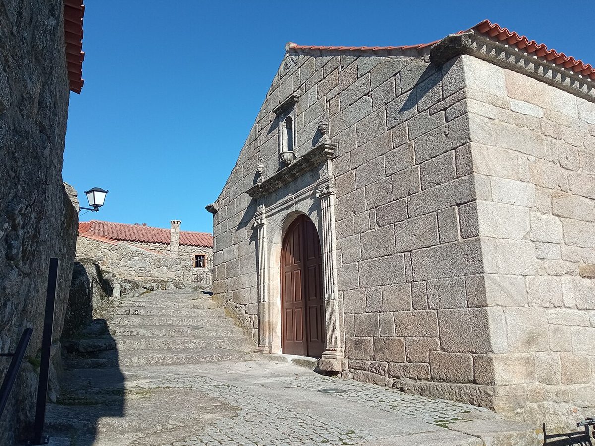
Verdict: two hours, ideally at the end of the day. It’s about 35 minutes from Belmonte, and the two make a natural pair.
Belmonte
Belmonte is a small hill town above the Cova da Beira with a castle and two remarkable stories. Pedro Álvares Cabral, who led the fleet that reached Brazil in 1500, was born here, and the town has a museum about the discovery. More remarkable is Belmonte’s Jewish community. After the forced conversions of 1497, a group of families here kept Jewish practices in secret, marrying among themselves and praying in their homes, for more than four centuries, until a Polish mining engineer, Samuel Schwarz, documented them in 1917. The community returned openly to Judaism in the late twentieth century, built a synagogue in the 1990s, and the town’s Jewish Museum tells the story. Verdict: the best history of any of the twelve villages; give it two or three hours.
Almeida
Almeida, a few kilometres from the Spanish border, is enclosed in one of the finest fortifications in Europe: a star-shaped ring of bastions, ravelins, moats and gates built in the seventeenth and eighteenth centuries. It was the scene of the 1810 siege, when the powder magazine exploded and the old castle disappeared, and you can still see where it stood. The town inside is quiet, almost sleepy, and the best way to appreciate it is to walk the ramparts and look down at the geometry. Verdict: a must for anyone interested in military history, and handsome enough for everyone else; allow two hours.
Castelo Rodrigo, Castelo Mendo and Marialva
Castelo Rodrigo sits on a hill near Figueira de Castelo Rodrigo with the ruined palace of Cristóvão de Moura at the top. Moura backed Philip II of Spain’s claim to the Portuguese throne in 1580, and when Portugal regained its independence in 1640, the locals burned his palace. The views from the walls run deep into Spain and down over the almond orchards, which flower in a wave of white and pink in February and March. Castelo Mendo, near Almeida, is a tiny walled village on a ridge above the Côa, with a medieval gate, a pillory and very few people. Marialva, near Mêda, is a ruined citadel on a rocky hill with a small lived-in village below; it’s romantic and photogenic but takes an hour at most. Verdict: Castelo Rodrigo is the pick of the three, and from there the Côa Valley rock art, at Vila Nova de Foz Côa, is within reach.
Trancoso
Trancoso is more town than village, which makes it the liveliest of the twelve. It’s still enclosed by its medieval walls and gates, and it’s where King Dinis married Isabel of Aragon in 1282. It was also home to Bandarra, a sixteenth-century shoemaker whose prophetic verses fed the Portuguese legend that the lost King Sebastião would one day return. The old Jewish quarter has the Casa do Gato Preto, a house carved with symbols that are read as Jewish. Verdict: a good place to stay or eat on a loop through the northern villages, with Marialva twenty minutes away.
Castelo Novo and Linhares da Beira
Castelo Novo is a quiet granite village on the slopes of the Serra da Gardunha, south of Fundão, with a small castle, a handsome baroque fountain from the reign of João V and the Alardo spring, whose water is bottled. Linhares da Beira, covered above, is the Historic Village closest to the Serra da Estrela itself. Verdict: pleasant stops rather than destinations.
Piódão
Piódão, in the Serra do Açor west of the Serra da Estrela, is the odd one out: a village of dark schist houses rather than granite, stacked up a steep terraced hillside around a white church. The window frames and doors are painted blue, and the story is that blue was the only colour the village shop ever stocked. It’s at the end of long, winding mountain roads, which kept it isolated for centuries and still put off day-trippers, and it’s at its most beautiful after dark, when the lights come on and the whole village looks like a nativity scene.
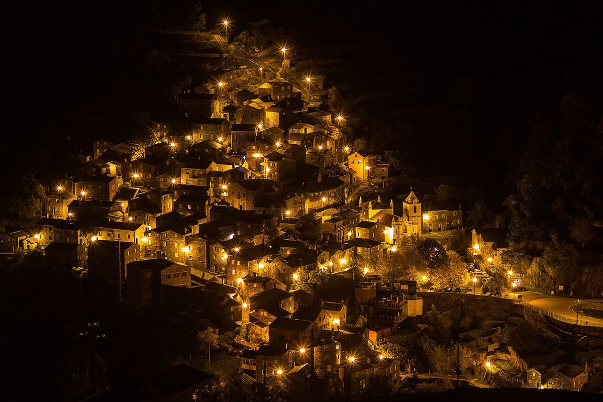
Verdict: spectacular, and worth the drive if you stay the night. It’s about an hour on mountain roads from Seia or Arganil, and two from Manteigas.
Many of these villages also have castles that rank among the country’s best; our guide to the best castles in Portugal puts Monsanto, Almeida and their neighbours alongside Guimarães, Óbidos and Sintra.
The schist villages (Aldeias do Xisto)
West of the Serra da Estrela, in the forested hills of the Serra da Lousã, the Serra do Açor and the Zêzere valley, a network of 27 small mountain villages built of schist, a dark, slate-like stone, has been restored as the Aldeias do Xisto. They’re smaller and more rustic than the Historic Villages: hamlets of a few stone houses, often reached by narrow roads or footpaths, many emptied in the twentieth century and partly revived as guesthouses, artists’ studios and cafés. The region was devastated by the wildfires of 2017, and you’ll still see the effects, but the villages and the woods are recovering.
- Talasnal, in the Serra da Lousã above the town of Lousã, is the easiest to reach and the prettiest: a cluster of restored schist houses in chestnut woods, with a couple of places to eat. It’s linked to its neighbours, Casal Novo and Chiqueiro, by short footpaths, and from Lousã you can walk up past the castle and the shrine of Nossa Senhora da Piedade.
- Cerdeira, nearby, is home to an arts-and-crafts residency and workshops.
- Gondramaz, above Miranda do Corvo, is a single lane of schist houses with sculptures tucked into its walls.
- Janeiro de Cima sits on the bank of the Zêzere, with a river beach.
- Fajão and Aigra Nova, in the hills around Pampilhosa da Serra and Góis, are wilder and further from anywhere.
Verdict: the Lousã villages are an easy half-day from Coimbra and a good warm-up for Piódão. For more on Coimbra and the rest of the region, see our central Portugal travel guide.
What to skip, and what’s overrated
- The Torre summit as a destination. It’s a car park with radar domes and souvenir shops. Drive the roads to it and from it; don’t plan your day around standing on it.
- Driving up on a snowy Sunday. Queues on the N339, full car parks, cars turned back for lack of chains, and road closures that can trap you on the wrong side of the mountain. Go midweek.
- Skiing as the reason for the trip. Fine for a day of fun, not for a ski holiday. If skiing is the priority, the resorts of the Spanish Pyrenees or the Alps are in another league.
- Cheese without the label. “Tipo Serra” cheese at Torre isn’t Queijo Serra da Estrela DOP. If you’re paying for the real thing, check the label.
- Roadside puppies. The Estrela Mountain Dog is a superb breed, but a puppy bought from a roadside stall is a bad idea on every level. If you want one, find a registered breeder.
- Covão dos Conchos at midday in August. Heat, no shade and a queue for the photo. Go at 8am, or in spring or autumn.
- All twelve Historic Villages in one trip. They’re spread across a huge area. Pick three or four, and stay in one.
- A day trip from Lisbon or Porto. It’s three hours each way from Lisbon. The mountain needs at least one night, and better two or three.
When to visit the Serra da Estrela and the interior
The interior has a continental climate by Portuguese standards: colder winters and hotter summers than the coast, with the mountain itself much cooler than the towns around it. There’s no bad season, but each one gives a very different trip.
| Season | Weather | Best for | Watch out for |
|---|---|---|---|
| Spring (April–June) | Mild, green, occasional rain; snow possible on the summit into April | Walking, waterfalls, flowering broom, Fundão cherries (late May–June), Monsanto’s Festa das Cruzes (3 May) | Changeable weather on the plateau |
| Summer (July–August) | Pleasant on the plateau, very hot in the towns and villages | Early walks, river beaches, Vale do Rossim, paragliding at Linhares | Wildfire risk and trail closures; crowds at Covão dos Conchos and Covão d’Ametade |
| Autumn (September–November) | Warm to cool, clear days, first snow late in the season | Autumn colour in the glacial valley, chestnuts, quiet villages, start of cheese season | Short days by November |
| Winter (December–March) | Cold; snow on the plateau, frost in the villages | Snow, skiing, the cheese at its best, fireside dinners, almond blossom at Castelo Rodrigo (Feb–Mar) | Road closures on the N339 and N338; weekend traffic |
My pick is late September to October, when the heat and fire risk have passed, the birches are turning and the villages are quiet, or May and June for walking. Come in January or February if snow is the point. For the rest of Portugal month by month, see our guide to the best time to visit Portugal, and for the interior’s festivals alongside the big city ones, our Portugal festivals calendar.
Getting there and getting around
By car
A car is close to essential. The mountain roads, the villages and the walking trailheads are barely served by public transport, and the Historic Villages are spread across a wide area. Approximate drive times:
| From | To | Approx. time | Route |
|---|---|---|---|
| Lisbon | Covilhã | ~3 h | A1 then A23 |
| Lisbon | Seia | ~3h15 | A1 then via Coimbra |
| Porto | Seia or Gouveia | ~2h15–2h30 | A1/A25 or via Viseu |
| Porto | Guarda | ~2 h | A25 |
| Coimbra | Seia | ~1h15 | IC6/N17 |
| Covilhã | Torre | ~30 min | N339 |
| Covilhã | Monsanto | ~1h15 | Via Fundão and Penamacor |
| Guarda | Almeida | ~40 min | A25, then local roads |
| Seia | Piódão | ~1 h | Winding mountain roads |
Good news on costs: the two motorways that serve the interior, the A23 (from the A1 to Castelo Branco, Covilhã and Guarda) and the A25 (from Aveiro to Viseu, Guarda and the Spanish border), have been toll-free since 1 January 2025 along with the other former SCUT motorways. The A1 from Lisbon or Porto is still tolled. Fuel was roughly €1.95–2.08 a litre for petrol in September 2026, and petrol stations thin out in the mountains, so fill up in Covilhã, Seia, Gouveia or Guarda. In winter, ask your hire company about snow chains before you set off; for everything else about driving here, see our getting around Portugal guide.
By train and bus
The Beira Baixa line runs from Lisbon through Castelo Branco and Fundão to Covilhã and on to Guarda, with Intercidades trains taking around four hours to Covilhã; check times and fares on cp.pt. The Beira Alta line from Coimbra to Guarda has been disrupted by a long modernisation programme in recent years, so check cp.pt for its current timetable before planning around it. Rede Expressos coaches run from Lisbon, Coimbra and Porto to Covilhã, Guarda, Seia and Gouveia. From any of those towns, though, you’d need taxis or a tour to reach the high mountain or most of the villages: there’s no regular bus to Torre. Covilhã without a car works for a city-and-snow trip if you take a taxi up to the slopes; for anything else, drive.
Where to stay
| Base | Best for | Downsides |
|---|---|---|
| Manteigas | Walkers, the glacial valley, a village feel | Small; fewer restaurants; mountain roads in every direction |
| Covilhã and Penhas da Saúde | Train arrivals, skiing, the most hotels | A steep working town rather than a pretty one |
| Seia, Sabugueiro or Loriga | The western side, cheese country, Lagoa Comprida | Further from the Historic Villages |
| Guarda | The northern Historic Villages and Spain | Cold in winter; the mountain is a drive away |
| Monsanto or Sortelha | Sleeping inside a Historic Village | Limited dining in the evening; steep lanes |
| Piódão | Seeing the village lit up at night | A long way from everything else |
Some of the most memorable places to stay are in converted buildings: the Pousada da Serra da Estrela in the old sanatorium at Penhas da Saúde, the Pousada Convento de Belmonte in a former convent just outside Belmonte, and the design-led Casa das Penhas Douradas high above Manteigas. In the villages, look for small guesthouses (casas de turismo rural) in restored stone houses, which are often the best value in this guide. Prices across the interior are lower than on the coast; our Portugal trip cost guide has a full breakdown of what things cost.
Itineraries: three days, five days and a week
Three days: the mountain
- Day 1: Drive from Lisbon on the A1 and A23 (about three hours), stopping at Belmonte for the Jewish Museum and the castle. Sleep in Manteigas.
- Day 2: Early start up the glacial valley on the N338 to Covão d’Ametade. Continue to Torre, then over the N339 to Lagoa Comprida and walk to Covão dos Conchos. Return via Sabugueiro for cheese, and back to Manteigas over Penhas Douradas.
- Day 3: Poço do Inferno in the morning, then Sortelha in the afternoon and back to Lisbon, or on to Monsanto to sleep.
Five days: the mountain and the southern villages
Take the three-day plan, sleep in Monsanto on night three, and spend day four on Monsanto at dawn, Idanha-a-Velha and the fossil trail at Penha Garcia. On day five, drive north via Castelo Novo to Guarda for the cathedral, or head back west via Castelo Branco to the A23 and Lisbon.
A week: the full interior
Add the northern villages and Piódão. Days one to four as above, then Guarda for a night (day five: Almeida, Castelo Mendo and Castelo Rodrigo), Trancoso the next (day six: Marialva and Linhares da Beira), and Piódão on the seventh night, either via Seia or approached from the schist villages of the Serra da Lousã on the way back to Coimbra. Alternatively, from Castelo Rodrigo it’s a short drive north to the Côa valley and on into the Douro Valley, which turns the interior into the middle of a much bigger loop.
The interior also slots into longer trips: our Portugal road trip routes include a Lisbon-to-Porto drive through the middle of the country, and the Portugal itinerary planner shows how two or three days here fit into a fortnight.
Practical tips for the interior
- Carry cash. Cards are widely accepted in the towns, but village cafés, cheese stalls and small guesthouses sometimes prefer cash, and cash machines are thin on the ground.
- Mind the opening hours. Many museums close on Mondays, and village restaurants may close one day a week and stop serving lunch at 3pm. Sunday lunch is the big meal; book if you can.
- Dress for the mountain, not the season. Torre can be 10°C colder than Covilhã, windy and fogbound in July. Pack a warm layer and a waterproof whenever you go up.
- Respect the fire rules. In summer, fire risk is extreme. No barbecues, no cigarettes thrown from cars, and obey any closures.
- Expect patchy signal. Mobile coverage disappears in valleys and on parts of the plateau. Download maps and trail tracks before you set off.
- Close gates and keep clear of flocks. This is working farmland, and the guardian dogs are serious.
- Book ahead in winter and for festivals. Snowy weekends, Christmas and New Year and Monsanto’s May festival fill the small amount of accommodation quickly.
For the essentials that apply across the country, from tipping to pharmacies, see our Portugal travel tips.
Frequently asked questions
Is the Serra da Estrela worth visiting?
Yes, if you have a car and at least two nights. It has mainland Portugal’s highest mountains, its finest glacial valley, its only ski runs, its best cheese and, nearby, the Historic Villages of Monsanto, Sortelha and Belmonte. It isn’t worth a rushed day trip from Lisbon or Porto.
How many days do you need in the Serra da Estrela?
Two or three days covers the glacial valley, the road over Torre, the Covão dos Conchos walk and a Historic Village or two. Five days to a week lets you add Monsanto, the northern border villages and Piódão without rushing.
When does it snow in the Serra da Estrela?
Snow usually arrives on the high plateau in November or December, and the best chance of snow on the ground is from late December to March. Amounts vary a lot from year to year, and it can still fall on the summit in April or May.
Can you ski in Portugal, and how much is a ski pass?
Yes, at the small ski area just below Torre, the only one in Portugal, usually open from late December or January into March. Third-party listings disagree on prices: one quotes €30 for an adult day pass in main season, another €25 in high season and €15 in low season. Confirm at the resort before you go.
Is the Serra da Estrela a national park?
No. It’s a natural park, created in 1976, and since 2020 a UNESCO Global Geopark. Portugal’s only national park is Peneda-Gerês in the north. There are no entry fees or gates; people live and farm inside the park.
What is the highest point in Portugal?
On the mainland it’s Torre, in the Serra da Estrela, at 1,993 m, which you can drive to. The highest point in the whole country is Mount Pico in the Azores, at 2,351 m.
How do you get to the Serra da Estrela from Lisbon or Porto?
By car it’s about three hours from Lisbon to Covilhã on the A1 and the toll-free A23, and about two and a quarter to two and a half hours from Porto to Seia or Gouveia. Intercidades trains run from Lisbon to Covilhã and Guarda in around four hours, but you’ll need a car or taxi to reach the mountain itself.
Where is the best place to stay in the Serra da Estrela?
Manteigas for walkers and the glacial valley, Covilhã for trains, skiing and the widest choice of hotels, and Seia or Loriga for the western side. For the Historic Villages, stay a night inside Monsanto or Sortelha, and use Guarda for the villages along the northern border.
What are the Historic Villages of Portugal?
Twelve restored fortified villages in the Beira interior: Almeida, Belmonte, Castelo Mendo, Castelo Novo, Castelo Rodrigo, Idanha-a-Velha, Linhares da Beira, Marialva, Monsanto, Piódão, Sortelha and Trancoso. Most guarded the old border with Spain, and a long-distance walking route, the GR22, links them.
Can you visit the Serra da Estrela without a car?
Only partly. Trains and coaches reach Covilhã, Guarda and Seia, and taxis can take you up to Torre and the ski area, but there’s no regular bus over the mountain or to most of the villages and trailheads. A tour or a hire car is the realistic option for anything beyond a city-and-snow trip.
Several of the quieter places around the mountain, including Sortelha, Belmonte, Idanha-a-Velha, Castelo Rodrigo and the Côa Valley, also appear on our map of Portugal’s off-the-beaten-path places, which links them into a four- to five-day route along the Beira frontier.
The Serra da Estrela is one of thirteen natural parks on the mainland, alongside Portugal’s single national park, Peneda-Gerês. Our guide to the national parks of Portugal ranks all fourteen and suggests a route linking the Serra da Estrela with the caves of the Serras de Aire, the Tejo Internacional and São Mamede.
Where to go next
- Central Portugal: Coimbra, Óbidos, Nazaré and the monastery route
- The best hikes in Portugal, from the Rota Vicentina to Peneda-Gerês
- Portugal’s castles, ranked
- Road trip routes through Portugal
- The Douro Valley, the natural next stop north
- The Alentejo, for the interior south of the Tagus
- The best things to do in Portugal
Photo credits
- The N338 climbing to the snow-dusted Cântaros above Manteigas (featured image) — Halley Oliveira, CC BY-SA 2.0, via Wikimedia Commons
- Covão dos Conchos, Serra da Estrela — larahcv, CC0, via Wikimedia Commons
- Snow below Cântaro Magro in the Serra da Estrela — JTRL78, CC BY-SA 4.0, via Wikimedia Commons
- Covão d’Ametade, Serra da Estrela — InêsSilvaNina, CC BY-SA 4.0, via Wikimedia Commons
- Sheep at the Feira do Queijo, Seia, 2022 — Hipersyl, CC BY-SA 4.0, via Wikimedia Commons
- Monsanto, central Portugal — Alvesgaspar, CC BY-SA 4.0, via Wikimedia Commons
- Sortelha — 80kmh, CC BY 4.0, via Wikimedia Commons
- Piódão at night — Tercio Leal, CC BY 2.0, via Wikimedia Commons
Ski-pass prices checked October 2026 against third-party ski listings, which disagree with each other; the resort’s own website does not publish a readable price list, so confirm at the ticket office. Motorway toll status and fuel prices checked September 2026. Drive times are approximate and assume clear roads. Last updated: October 2026.